How Big Is New Zealand? 268,021 km², Bigger Than the UK
New Zealand covers 268,021 km², about 10% larger than the United Kingdom. Drag it onto any country on our interactive map to see its real size.
Map2Maps Team
New Zealand's actual size is routinely underestimated. Tucked into the corner of most world maps, this island nation is larger than people expect.
Key Takeaways: - New Zealand covers 268,021 km², about 10% larger than the United Kingdom - Mercator actually enlarges it by roughly 1.33x, so map placement rather than projection is what shrinks it - Its Exclusive Economic Zone is around 15 times its land area
How Big is New Zealand Compared to the UK?
About 10% larger. At 268,021 km² (103,483 sq mi), New Zealand outsizes the United Kingdom's 243,610 km² (CIA World Factbook, 2026).
The population comparison runs the other way, and far more steeply. New Zealand holds around 5.2 million people; the UK holds roughly 68 million.
Dimensions and Coastline
- Dimensions: 1,600 km north-south, 400 km east-west at its widest
- Coastline: Over 15,000 km, longer than the entire US west coast
- Island ranking: 6th largest island country globally
That elongated shape, spread between 34°S and 47°S, is part of why the country is so hard to size up at a glance: there is no compact block for the eye to latch onto.
Why Does New Zealand Look So Small on Maps?
Not because of projection distortion, which is the answer most people expect. Mercator actually enlarges New Zealand. Scale factor is the multiplier a projection applies at a given latitude, and at 41°S it comes to about 1.33.
The real cause is placement. The country sits at the far right edge of most world maps, frequently cropped, often pushed into a corner alongside a scale bar or legend, and sometimes omitted from small-format maps altogether. It is also compared visually against Australia, which is 28 times larger and sits immediately next door.
Position on the page, in other words, does what the projection does not.
New Zealand (268,021 km²) is bigger than the United Kingdom (243,610 km²) and almost as big as Italy (301,340 km²).
How Does It Compare to Other Countries?
Countries larger than New Zealand:
- Japan: 377,975 km² (41% larger)
- Germany: 357,022 km² (33% larger)
- Italy: 301,340 km² (12% larger)
Smaller than New Zealand:
- United Kingdom: 243,610 km² (9% smaller)
- Romania: 238,397 km² (11% smaller)
- Greece: 131,957 km² (about half the size)
Which Island is Bigger?
The South Island, and the two are geologically quite different.
The South Island covers 150,437 km² and is by far the more mountainous. The Southern Alps run its length, with Aoraki / Mount Cook reaching 3,724 m and eighteen peaks above 3,000 m. Glaciers descend into rainforest on the wet west coast, while the eastern Canterbury Plains lie in a pronounced rain shadow. Fiordland in the southwest ranks among the wettest places on Earth, with parts receiving over 6,000 mm annually.
The North Island covers 113,729 km² and holds roughly three-quarters of the population despite being smaller. It is volcanically active, sitting over the Taupō Volcanic Zone, and Lake Taupō itself fills a caldera formed by one of the largest eruptions of the past 100,000 years. Ruapehu, at 2,797 m, is both the island's highest point and an active volcano.
Explore for Yourself
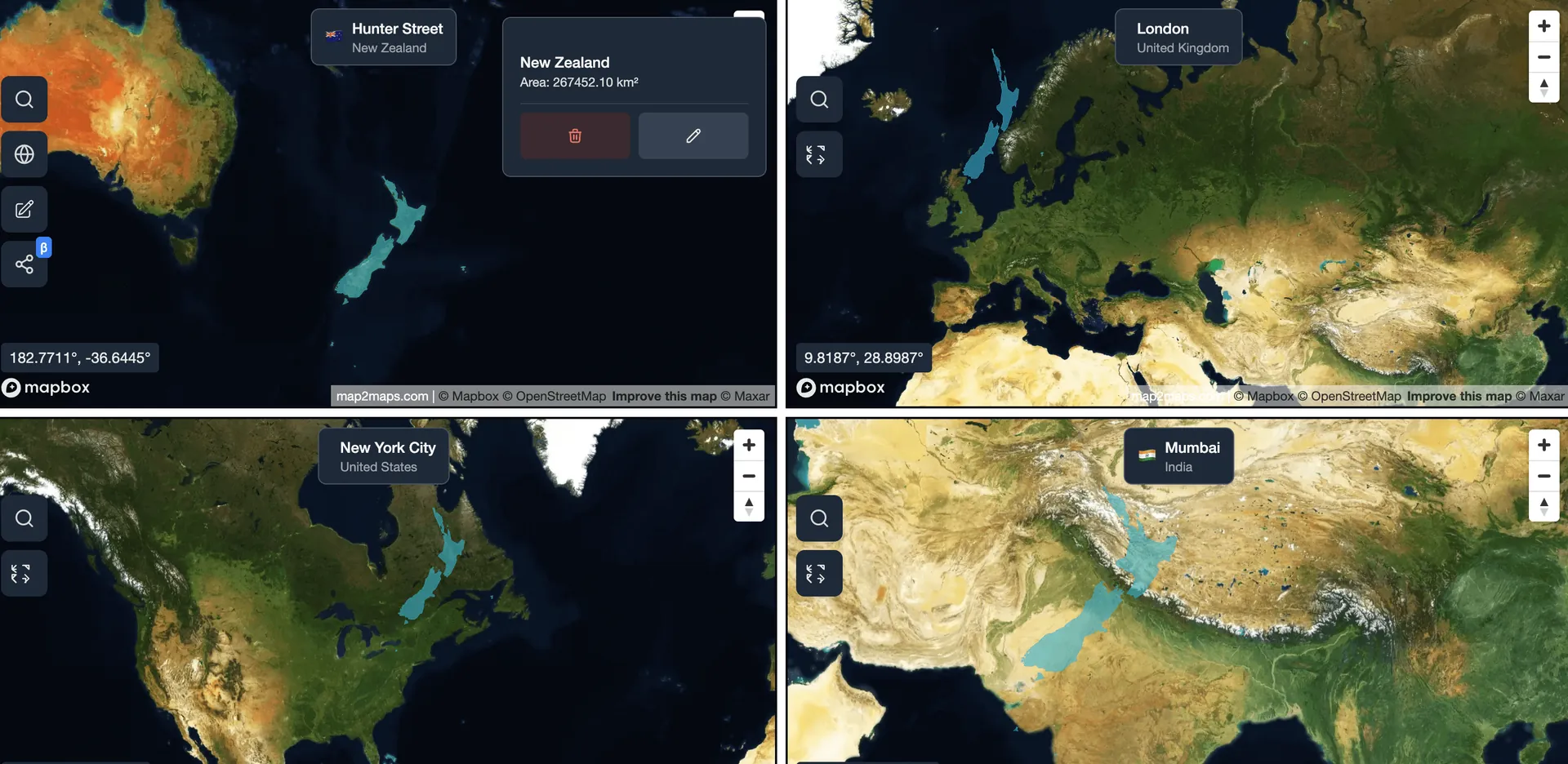
Explore this comparison on our interactive map tool
Explore Interactive MapWhen we measured New Zealand's boundary geodesically and dropped it over Europe, it comfortably covered the United Kingdom with room left over. Try the overlay above.
How Much Territory Does New Zealand Really Have?
Far more than its land area suggests.
An Exclusive Economic Zone is the maritime area a country controls for resource purposes, and New Zealand's covers roughly 4 million km². That is about 15 times the land area and one of the largest EEZs of any country. Add the continental shelf claim and the figure grows further.
The reason is geological. New Zealand is the exposed portion of Zealandia, a largely submerged continental fragment of roughly 4.9 million km². Around 94% of Zealandia sits underwater, and the visible 6% is what appears on maps. By this measure New Zealand is not a small country with a long coastline. It is a mostly submerged continent with a small dry part.
Compare Any Country on Earth
Save unlimited comparisons and return to them whenever you need them, with priority support included.
How Densely Populated Is It?
Lightly, by European standards. Around 5.2 million people live in the country, at roughly 19 per km² (World Bank Open Data, 2026), with Auckland alone accounting for about a third of the national total and roughly 87% of the population living in urban areas.
For comparison, the United Kingdom is 9% smaller yet holds roughly 68 million people at about 280 per km². So New Zealand fits into a similar footprint at a fraction of the density, which explains much of why the country reads as empty to visitors who arrive expecting a European sense of scale. The South Island, despite being the larger of the two, holds under a quarter of the people, so the emptiness is concentrated exactly where the terrain is most dramatic. Drive the length of the West Coast and you pass through a region larger than Wales holding a population smaller than a single London borough, on a road that runs for hundreds of kilometres between towns of any size.
The Isolation Factor
Scale here is as much about remoteness as area. Australia, the nearest substantial neighbour, lies about 2,000 km west across the Tasman Sea, and the nearest significant landmass in any other direction is considerably farther.
That isolation shaped the ecology first. Its fauna evolved without land mammals, producing flightless birds such as the kiwi, kākāpō, and the extinct moa. The economy followed, leaning historically on high-value exports that justify the freight cost.
Economy and Land Use
- GDP: ~$250 billion
- GDP per capita: ~$48,000
- Major industries: Dairy, meat and wool, horticulture, tourism, forestry, film production
- Land use: Roughly 40% agricultural, about 38% forest
The Department of Conservation administers roughly a third of the national land area, among the highest proportions of protected land anywhere. Fiordland National Park alone covers 12,607 km², larger than several sovereign states.
More Than Meets the Eye
- About 10 sheep for every person
- The only country with no native land mammals other than bats
- The Lord of the Rings and Hobbit trilogies showcased its landscapes
- Ninety Mile Beach is actually about 88 km long
- Wellington is the southernmost capital city in the world
The Takeaway
This is a country substantially larger than its corner-map positioning suggests, with considerable geographic diversity across its two main islands. At 268,021 km² it outsizes the United Kingdom, approaches Italy, and stretches across 13 degrees of latitude, a north-south range comparable to the distance from Rome to Copenhagen.
And that is only the part above water.
Sources and method
- Country and island areas: CIA World Factbook
- Population and GDP: World Bank Open Data
- National statistics: Stats NZ
- Boundary geometry: Natural Earth
Method: boundaries come from Natural Earth 3.3.0 (1:50m). Areas are computed with Turf's geodesic area function over the polygon geometry, so they do not depend on the Web Mercator projection used for display. Figures include inland water and follow each source's treatment of disputed boundaries.
Note: Land area excludes the Exclusive Economic Zone and outlying territories such as the Ross Dependency. Island areas are for the North and South Islands only and exclude Stewart Island and the offshore groups.
Figures checked 17 August 2026.
Frequently Asked Questions
How big is New Zealand compared to the UK?
Why does New Zealand look so small on world maps?
Which New Zealand island is bigger?
Is New Zealand part of a submerged continent?
How far is New Zealand from Australia?
Use our interactive map tool to compare New Zealand with any country or region. For more island comparisons, check out Madagascar or Italy vs New Zealand, or see continental differences in Brazil vs India and Argentina vs Algeria.
Related Articles
Is Australia Bigger Than the USA? No, the US Is 28% Larger
Australia covers 7,692,024 km² and the United States 9,833,517 km², about 28% larger. Drag Australia onto the US on our interactive map to see it.
Italy vs. New Zealand: Two Boot-Shaped Nations Compared
Compare Italy and New Zealand, two uniquely shaped countries defined by mountains, coastlines, and stunning natural beauty despite being on opposite sides of the world.
Alaska vs. Australia Size Comparison
Alaska covers 1,717,856 km², about 22% of Australia. Remove Alaska from the US and the rest is just 5.5% bigger than Australia, not 28%.
Explore for Yourself
Ready to dive deeper? Compare countries and see how Web Mercator changes their apparent size at different latitudes.
Sponsored
Products we use and recommend
Support Map2Maps by checking out these tools.
Sponsored
Send money internationally with Wise
Save up to 6x on international transfers with real exchange rates
Try WiseSponsored
Learn Languages with Langi.app
Read bite-sized stories with audio to learn languages at your level
Start LearningSponsored
Ship faster with bunny.net
Global CDN, storage, and media delivery tools that keep websites and video fast worldwide.
Explore bunny.netSponsored
Move faster with Raycast
A keyboard-first launcher with extensions, snippets, and AI to speed up everyday work.
Try RaycastSponsored
Build referral programs with Refgrow
A referral program platform for SaaS and AI products with automated tracking, commission management, and payouts.
Explore Refgrow