China vs. United States: Which Superpower is Actually Bigger?
Compare the true sizes of China and the United States, two global superpowers with surprisingly similar land areas that appear different on standard maps.
Map2Maps Team
China and the United States are the world's two largest economies and most influential nations. Their size comparison is close and contested.
The Numbers: China vs. United States
- China's area: 9,596,961 square kilometers (3,705,407 square miles)
- United States' area: 9,833,517 square kilometers (3,796,742 square miles)
- Population: China ~1.4 billion, USA ~335 million
- Location: China in East Asia, United States in North America
Quick Comparison: - The USA is about 2.5% larger than China - China has over 4 times the US population - Both countries rank 3rd and 4th globally by land area (depending on measurement method)
The Great Size Debate
The exact rankings are contentious. Different measurement methods produce different results:
Total Area (including water):
- Russia
- Canada
- United States (9,833,517 km²)
- China (9,596,961 km²)
Land Area Only:
- Russia
- Canada
- China (9,326,410 km²)
- United States (9,147,593 km²)
The difference hinges on whether you count territorial waters, coastal waters, and inland lakes. By total area, the USA edges ahead. By land area alone, China takes third place.
The size difference between these two superpowers is less than 3%. That's essentially a rounding error when measuring millions of square kilometers.
Geographic Diversity
China:
- Dimensions: 5,026 km east-west, 4,032 km north-south
- Coastline: 14,500 km
- Terrain: Mountains (west), deserts (north), plains (east), plateaus (southwest)
- Highest point: Mount Everest (8,849 m) on the Nepal border
- Major features: Himalayas, Tibetan Plateau, Gobi Desert, Yangtze River
United States:
- Dimensions: 4,500 km east-west (contiguous), 2,700 km north-south
- Coastline: 19,924 km
- Terrain: Mountains (west and east), plains (center), deserts (southwest)
- Highest point: Denali (6,190 m)
- Major features: Rocky Mountains, Mississippi River, Great Lakes, Great Plains
Both countries span large distances and include varied geographic features.
Compare Any Country on Earth
Save your favorite comparisons, access advanced features, and get updates when new articles are published.
Climate Zones
China spans multiple climate zones: tropical in the south (Hainan), subtropical along the coast, temperate in the center, and subarctic in the northeast. The Tibetan Plateau creates its own microclimate. The Gobi Desert experiences extreme temperature swings.
The United States offers similar diversity: Arctic in Alaska, tropical in Hawaii and Florida, arid deserts in the Southwest, temperate forests in the East, and Mediterranean in California. Both countries experience virtually every climate type found on Earth.
Sponsored
Products we use and recommend
Support Map2Maps by checking out these tools.
Send money internationally with Wise
Save up to 6x on international transfers with real exchange rates
Learn Languages with Langi.app
Read bite-sized stories with audio to learn languages at your level
Ship faster with bunny.net
Global CDN, storage, and media delivery tools that keep websites and video fast worldwide.
Move faster with Raycast
A keyboard-first launcher with extensions, snippets, and AI to speed up everyday work.
Build referral programs with Refgrow
A referral program platform for SaaS and AI products with automated tracking, commission management, and payouts.
Population: The Defining Difference
While similar in size, their populations differ considerably.
China: 1.4 billion people (148 per km²)
- Most populous country globally (recently overtaken by India)
- Population concentrated in the eastern third of the country
- Cities like Shanghai, Beijing, and Guangzhou each have 10+ million residents
United States: 335 million people (36 per km²)
- Third most populous country globally
- More evenly distributed, though coasts are denser
- Only 10 cities exceed 1 million residents
China packs over 4 times as many people into essentially the same space.
The Empty West vs. The Populated East
Both countries share a notable pattern: densely populated east, sparsely populated west.
China's Population Line: The Heihe-Tengchong Line divides China diagonally. East of this line (43% of area) lives 94% of the population. West of it (57% of area) lives just 6%. The western regions of Tibet, Xinjiang, and Inner Mongolia are mountainous, desert, or plateau.
America's 100th Meridian: This rough line divides the country into eastern (humid) and western (arid) regions. While not as stark as China's divide, the western states remain far less populated than the east. Population clusters on the coasts and in the Midwest.
Economic Powerhouses
China:
- GDP: ~$18 trillion (2nd largest globally)
- Major industries: Manufacturing, technology, construction, exports
- Economic model: State-guided market economy
- Growth rate: Historically rapid, now moderating
United States:
- GDP: ~$27 trillion (largest globally)
- Major industries: Technology, finance, services, manufacturing
- Economic model: Market-based capitalist economy
- Global influence: Dollar is world's reserve currency
Combined, these two nations represent over 40% of global GDP.
Interactive Exploration
Explore this comparison on our interactive map tool
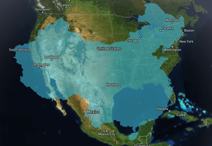
Explore Interactive MapOverlay China and the United States to see how closely they match in size.
Time Zones: A Political Quirk
Despite spanning similar distances east to west, the countries handle time zones differently:
United States: Uses 6 time zones (including Alaska and Hawaii). The contiguous 48 states span 4 time zones, reflecting the country's width.
China: Uses a single time zone (UTC+8) for the entire country. This means sunrise in western Xinjiang occurs at 10 AM "official" time, while eastern Shanghai sees sunrise around 6 AM. This political decision emphasizes national unity despite geographic impracticality.
The Mercator Effect
The Mercator projection distorts both countries, but differently.
China (18-53°N) sits at latitudes that experience moderate distortion. Southern China appears close to its true size, while the north stretches somewhat.
The United States (25-49°N in the contiguous states, plus Alaska at 51-71°N) experiences similar distortion in the lower 48, but Alaska gets stretched more, making the entire country appear larger relative to China.
On a Mercator map, the USA often looks noticeably bigger than China. In reality, they're nearly identical.
Agriculture and Arable Land
Despite similar total sizes, their usable agricultural land differs.
China: Only about 11% of land is arable. The eastern plains are highly productive, feeding 1.4 billion people. Terraced rice paddies cover hillsides. Deserts and mountains dominate the west.
United States: About 17% is arable, with vast prairies and plains forming the "breadbasket." The USA exports large grain quantities globally. More of the land is naturally suited for farming.
Fun Facts
China:
- Has 5 of the world's 10 longest rivers
- The Tibetan Plateau is called the "Roof of the World"
- Contains the world's highest desert (Taklamakan)
- Shanghai has more skyscrapers than any other city globally
- The Great Wall stretches 21,196 km (though much is in ruins)
United States:
- Has more climate diversity than any country except possibly Russia
- Yellowstone's supervolcano could cause a global catastrophe if it erupted
- The Mississippi drains 41% of the contiguous United States
- Alaska alone is larger than all but 18 countries
- Has the world's largest economy by nominal GDP
Wilderness and National Parks
Both countries preserve large natural areas, though their approaches differ.
China has designated numerous nature reserves and national parks, though access is often restricted. The Tibetan Plateau and western deserts remain largely untouched. Recent conservation efforts have increased protection.
The United States pioneered the national park concept. Parks like Yellowstone, Yosemite, and the Grand Canyon attract millions annually. The National Park System protects over 340,000 km² of wilderness.
Infrastructure and Connectivity
China has built extensive infrastructure over the past 30 years:
- World's largest high-speed rail network (40,000+ km)
- Extensive highway systems connecting major cities
- Large urban subway systems
- Three Gorges Dam (world's largest hydroelectric plant)
The United States built earlier but is now aging:
- Extensive interstate highway system (75,000+ km)
- Limited passenger rail (Amtrak serves limited routes)
- Extensive freight rail network
- Major airports connecting all regions
Conclusion
China and the United States are virtually identical in size. Depending on how you measure, they're within 2-3% of each other. Both are continental-scale nations with wide diversity in geography, climate, and terrain.
The USA has more land area, a larger economy, and lower population density. China has more people, faster recent growth, and increasing global influence. Together, they're the defining powers of the 21st century, and they're almost exactly the same size.
Frequently Asked Questions
Is China bigger than the United States?
Why does China use only one time zone?
Which country has more people?
What is the 3rd largest country in the world?
Why is most of China's population in the east?
Which country has a larger economy?
Use our interactive map tool to compare China and the United States with any country or region. Also check out Brazil vs. India for another comparison of major developing nations, or Canada vs. Europe for more continental-scale insights.
Related Articles
Mexico vs. Indonesia: Size Comparison of Two Tropical Powerhouses
Discover how Mexico and Indonesia compare in size despite their very different geographies. One is a continental landmass, the other an archipelago of thousands of islands.
How Big is Australia Compared to the United States?
Discover the surprising size difference between Australia and the United States, and how the Mercator projection affects our perception of both countries.
Norway vs. Japan: Comparing Two Long, Narrow Island Nations
Discover how Norway and Japan compare in size. These two elongated countries are defined by mountains, coastlines, and seafaring cultures despite very different climates.
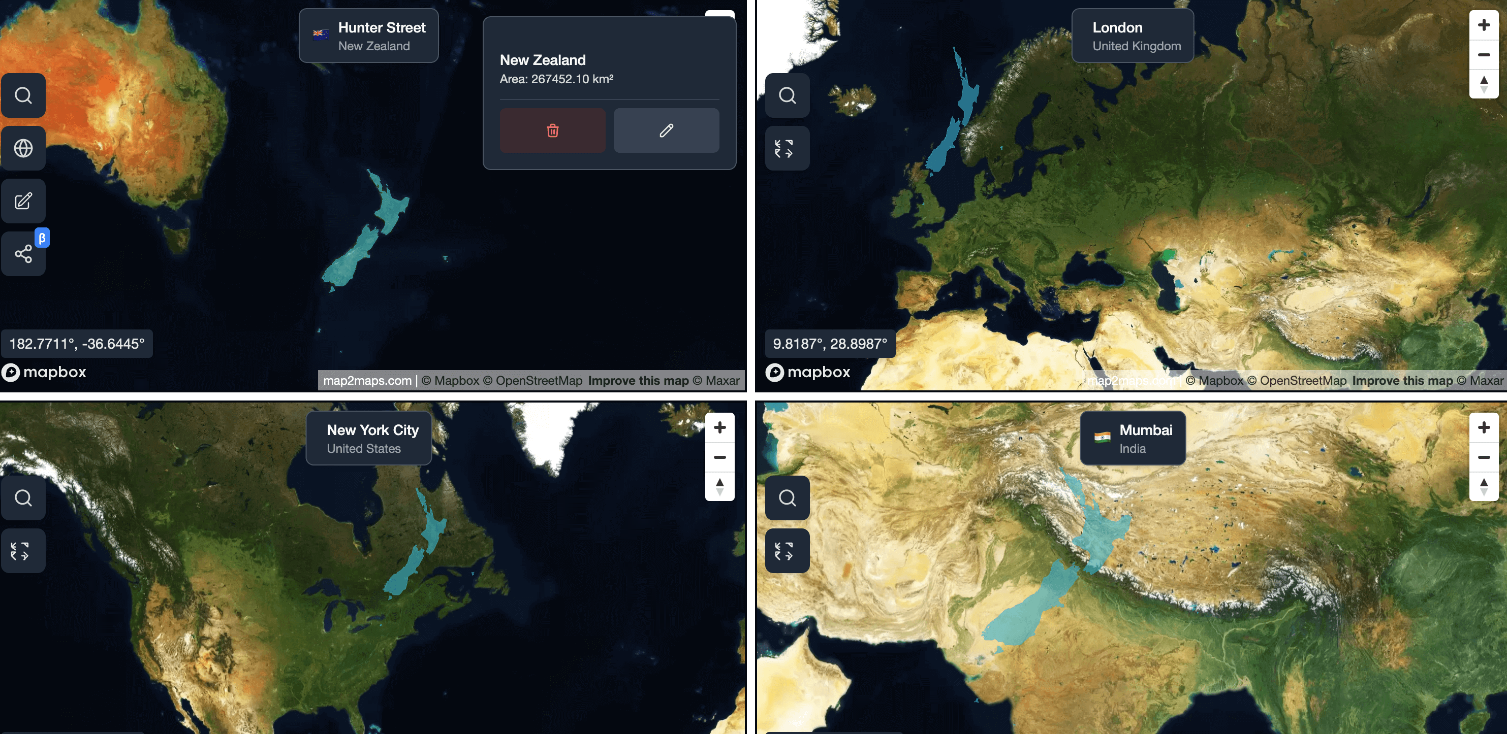
Explore for Yourself
Ready to dive deeper? Use our interactive tools to compare countries, explore map projections, and see these geographic concepts in action.